Hurricane Erin moves away from the East Coast, but it remains a coastal threat
Hurricanes Storms See all topics Follow
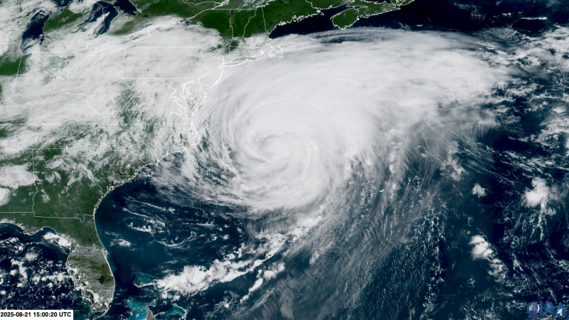
Erin is moving away from the United States but don’t breathe a sigh of relief just yet: The massive hurricane is still churning up the Atlantic Ocean, keeping dangerous conditions in place for more than 1,000 miles of the East Coast.
Hurricane Erin has been a major disruption for coastal communities this week – especially North Carolina’s Outer Banks – even without making landfall. It’s stirred up life-threatening rip currents that prompted dozens of rescues and sent rushing water and sand over coastal roads from the Southeast all the way up through Massachusetts. Erin could keep pushing the ocean onto coastlines through at least Friday.
The hurricane made its closest approach to US soil Wednesday night as it skirted just 200 miles from the Outer Banks. It brought serious coastal flooding that has eroded beaches and shut down parts of the highway linking the barrier islands.
Erin’s northeast turn away from the US began early Thursday and it was accelerating away from the coast as of Friday morning.
Here’s what to expect from Erin next and what mark it’s already made.
Coastal flood threats aren’t over as dangerous seas expand
Erin is a Category 1 hurricane tracking northeast, away from the East Coast.
Its tropical storm-force winds reached nearly 575 miles from end-to-end Thursday morning, making Erin larger than 90% of tropical systems that have roamed the same part of the Atlantic at a similar strength, according to the National Hurricane Center. By Friday morning, the storm’s wingspan had an even bigger reach.
All tropical storm and storm surge warnings for the US were discontinued late Thursday. Erin delivered tropical storm-force wind gusts of 40 to 50 mph to much of the Outer Banks early Thursday morning and some 45 mph gusts to coastal Virginia and Maryland. A tropical storm warning remains in effect for Bermuda.
As Erin moved farther north, the hurricane teamed up with high tide and sent flood waters rushing into coastal areas from South Carolina all the way up the coast into New Jersey, New York and Massachusetts.
New Jersey Gov. Phil Murphy declared a state of emergency Thursday afternoon before tidal flooding prompted several road closures and water rescues in Atlantic City and Wildwood.
Delaware Gov. Matt Meyer said the state’s Emergency Operations Center has been activated in response to flooding. “Crews are staged and ready—but we need you to do your part. Stay off the beaches tonight and keep clear of flood-prone roads,” Meyer said in a social media post Thursday night.
Tidal waters inundate Atlantic City streets Thursday evening. City of Atlantic City
The rip current risk also remains high through Friday for most of the East Coast. An elevated risk will likely persist at least through the weekend.
More than 70 people were rescued from rip currents in North Carolina this week, before Erin’s closest pass.
“Some of these rips are pulling six to eight people out at a time,” Wrightsville Beach ocean rescue director Sam Proffitt told WILLHOST, describing the conditions as “very strong” and “dangerous.” Proffitt noted the volume of water moving and funneling out is so intense, it “really doesn’t matter how good of a swimmer you are.”
Many popular beaches up and down the East Coast – including in North Carolina, Maryland, Virginia, Delaware, New York and New Jersey – have restricted swimming this week as a result.
North Carolina bore the brunt of Erin
Ocean waves slam into the shore during high tide on Wednesday evening in Buxton, North Carolina. Lighthouse View Oceanfront Lodging
North Carolina remains under a state of emergency after Erin sent large waves crashing into the coastline — impacting seaside homes and businesses — and spurred significant coastal flooding in its Outer Banks Wednesday.
Evacuations were ordered ahead of the hurricane for parts of the Outer Banks, including the Hatteras and Ocracoke islands. The North Carolina Ferry System evacuated over 2,200 people and 1,100 cars from Ocracoke Island on Wednesday alone.
Officials had warned earlier in the week that the region’s Highway 12 – the slim, scenic stretch of road connecting the barrier islands – could become completely inaccessible. They were correct.
Still images from DriveNC.gov traffic cameras show water standing on NC-12 after it flowed over the protective dunes. The camera is north of Hatteras, North Carolina. North Carolina DOT
Highway 12 was closed as of Thursday morning after sand, water and debris covered sections of the roadway overnight. The force of the hurricane-whipped ocean breached and flattened sand dunes designed to protect the roadway in parts of Hatteras and Ocracoke, according to the North Carolina Department of Transportation.
Crews are working to clear the highway, but the transportation department had no estimate on when it would reopen as of Thursday afternoon.
On Friday, North Carolina Gov. Josh Stein will travel to Dare County, where Hatteras Island is located, to assess the damage Erin caused, according to a Thursday news release.
Will Erin have a successor?
Erin will lose steam as it heads for the northern Atlantic and enters more hostile atmospheric conditions this weekend and could be a tropical storm by Sunday – a far cry from the violent Category 5 hurricane it was for a time last weekend.
Erin became one of the fastest rapidly intensifying storms in Atlantic history after it strengthened from a Category 1 to a Category 5 in just 24 hours. Hurricanes are rapidly intensifying more frequently as the oceans and atmosphere warm in a world polluted by fossil fuels.
Odds are Erin won’t be the last rapidly intensifying Atlantic hurricane of the season — last year had nine.
The next few days could see more tropical systems develop in Erin’s wake.
An area of showers and thunderstorms near the Caribbean’s Leeward Islands has a high chance of forming into at least a tropical depression this weekend, according to the NHC. Where it goes from there isn’t clear, but early indications are it may take a curve similar to Erin.
Another area of stormy weather over the open tropical Atlantic has a medium chance to develop into a short-lived tropical depression by the end of the week.
Share this content: